Flight Plan Drone Image

The Differences in Situational Awareness When Flying a Drone, BVLOS, EVLOS, and VLOS

You may think that flying a drone is a straightforward task, but when it comes to situational awareness, there are distinct differences depending on whether you are flying beyond visual line of sight (BVLOS), extended visual line of sight (EVLOS), or visual line of sight (VLOS).

Each category presents unique challenges and considerations that drone pilots must be aware of in order to ensure safe and successful flights.

What is Situational Awareness when referring to drone flights?

What exactly is situational awareness when it comes to flying a drone?

Situational awareness refers to your ability to perceive and understand the environment in which you’re operating your drone. It involves being aware of your surroundings, the potential risks and obstacles, and the actions of other aircraft or objects in the airspace. Essentially, it means being fully present and attentive to everything that’s happening around you while piloting your drone.

Having situational awareness is crucial for safe and successful drone flights. It allows you to anticipate and respond to any potential hazards or changes in the environment, ensuring that you can navigate your drone safely and avoid collisions or accidents. For example, if you’re aware of a nearby tree or power line, you can adjust your flight path accordingly to avoid any potential obstacles.

To maintain situational awareness, you need to constantly monitor your surroundings and pay attention to any changes or developments. This includes keeping an eye on the weather conditions, the presence of other aircraft, and any potential hazards in the area. By staying vigilant and alert, you can make informed decisions and adjust your flight plan as necessary.

In addition to visual observation, situational awareness also involves using technology and tools to enhance your understanding of the environment. This may include utilizing GPS systems, radar, or other sensors to gather information about your surroundings. By combining these technological aids with your own observations, you can obtain a comprehensive picture of the airspace and make informed decisions about your drone’s flight path.

What is BVLOS?

BVLOS, or Beyond Visual Line of Sight, is a term used to describe a type of drone operation where you aren’t able to directly see the drone with your own eyes. In other words, the drone is flying beyond the range of your visual line of sight. This can be achieved through the use of advanced technologies such as GPS, radar, and onboard cameras.

When flying a drone BVLOS, you rely heavily on the data and information provided by these technologies to maintain situational awareness. This means that you need to have a clear understanding of the drone’s position, altitude, speed, and any potential obstacles or hazards in its flight path. Without direct visual contact with the drone, you must rely on the information displayed on the controller, spotters with binoculars following the drone or ground station to make informed decisions.

BVLOS operations are typically conducted for various applications such as aerial photography, surveying, inspection of infrastructure, and delivery services. However, it’s important to note that BVLOS operations are highly regulated and require special permissions and certifications from aviation authorities. This is because operating a drone beyond visual line of sight introduces additional risks and challenges, such as the increased potential for collisions with other aircraft or objects.

To ensure the safety and success of BVLOS operations, it’s crucial to have a robust system in place for monitoring the drone’s flight, maintaining communication with the drone, and managing any potential risks. This includes having redundant systems, establishing clear communication protocols, and implementing effective emergency procedures.

WHat is EVLOS?

EVLOS, or Extended Visual Line of Sight, refers to a type of drone operation where the drone is flown within an extended range of direct visual contact. In EVLOS operations, the drone pilot maintains direct visual contact with the aircraft throughout the flight, but the distance between the pilot and the drone is greater than in VLOS (Visual Line of Sight) operations. A spotter with binoculars or other visual aids may also be used.

When flying a drone in EVLOS, the pilot relies on visual cues to navigate and maintain situational awareness. Although the drone is flown at an extended range, it’s still within the pilot’s line of sight. This allows the pilot to visually monitor the drone’s position, altitude, and surroundings, ensuring safe operation.

EVLOS operations offer several advantages over VLOS operations. By extending the range of direct visual contact, drone operators can cover larger areas and conduct more complex missions. This is particularly useful in applications such as aerial surveying, infrastructure inspection, and search and rescue operations.

To ensure safety during EVLOS operations, it’s crucial for the pilot to have a clear understanding of the drone’s capabilities and limitations. It’s also important to have a well-defined operational plan, including pre-flight checks, airspace authorization, and contingency procedures.

Maintaining proper communication and coordination with other airspace users, such as manned aircraft and other drones, is also essential.

What is VLOS?

To maintain safety and situational awareness when flying a drone, it’s important to understand the concept of Visual Line of Sight (VLOS). VLOS refers to the ability of the drone operator to maintain a direct visual contact with the aircraft at all times during the flight. This means that you must be able to see the drone with your own eyes, without the assistance of any devices like binoculars or screens.

When flying with VLOS, you have a clear line of sight to your drone, allowing you to visually track its movements, detect any potential obstacles or hazards, and make real-time adjustments as needed. This direct visual contact is crucial for maintaining control and avoiding collisions, ensuring the safety of people, property, and other aircraft in the vicinity.

The Federal Aviation Administration (FAA) in the United States requires drone operators to maintain VLOS when flying recreationally or commercially. This regulation is in place to minimize the risk of accidents and ensure responsible drone operations. By keeping the drone within your visual line of sight, you’re able to maintain a higher level of situational awareness, reducing the chances of losing control or causing harm.

It is important to note that VLOS has its limitations. Factors such as distance, weather conditions, and the size of the drone can affect the visibility and range of your line of sight. It’s crucial to fly within the prescribed limits and take into consideration any local regulations or restrictions that may be in place.

Drone night flight Jätkäsaari Evening

What are the regulations for drone flights in Finland?

As a drone operator in Finland, it’s crucial to comply with the laws and guidelines set by the Finnish Transport and Communications Agency (Traficom).

In Finland, the regulations for drone flights are governed by the Drone Act, which came into effect in 2019. According to these regulations, all drones weighing over 250 grams must be registered with Traficom. This registration ensures that the authorities can track and identify the owner of the drone in case of any incidents or violations. Additionally, drone operators are required to pass an online exam and obtain an operator’s certificate before flying their drones.

When it comes to the operation of drones, there are certain restrictions in place. Drones mustn’t be flown higher than 150 meters above ground level without special permission. It’s also prohibited to operate drones in controlled airspace, near airports, or in restricted areas without proper authorization.

Furthermore, drone operators must always maintain visual line of sight (VLOS) with their drones. This means that the drone must always be within the operator’s sight, without the aid of binoculars or other devices. Flying beyond VLOS, known as Beyond Visual Line of Sight (BVLOS), requires special permission from Traficom.

These regulations are constantly evolving, and it’s the responsibility of drone operators to stay updated with any changes or additional requirements that may be introduced. By adhering to these regulations, drone operators can ensure the safety of their flights and avoid any legal issues in Finland.

What are the regulations for drone flights in Europe?

The regulations for drone flights in Europe vary across different countries and are governed by their respective national aviation authorities. As a drone pilot, it’s important to be aware of and comply with these regulations to ensure safe and legal operations.

In general, the European Union Aviation Safety Agency (EASA) has developed common rules for drone operations in Europe. These rules apply to all member states and aim to harmonize the regulations to promote safety and facilitate cross-border operations.

One of the key regulations is the categorization of drone operations based on the level of risk involved. Drones are classified into different categories, such as open, specific, and certified. The category determines the requirements for pilot competency, equipment, and operational restrictions.

For open category operations, which include low-risk flights, the regulations are relatively less stringent. However, there are still certain limitations, such as maximum altitude and distance from people and buildings. Additionally, drones weighing more than 250 grams need to be registered with the national aviation authority.

Specific category operations involve higher risks and require an operational authorization from the national aviation authority. This authorization is based on a risk assessment that considers factors like the location, airspace, and complexity of the operation.

Certified category operations involve drones with high risks, such as those used for commercial transport or surveillance purposes. These operations require a full certification process and compliance with more extensive regulations.

It is important to note that each European country may have additional national regulations on top of the common rules established by EASA. Therefore, as a responsible drone pilot, you should always check and adhere to the specific regulations of the country you’re flying in.

What are the regulations for drone flights in the UK?

What regulations govern drone flights in the UK?

Drone flights in the UK are regulated by the Civil Aviation Authority (CAA). The CAA has established a set of rules to ensure the safe and responsible operation of drones in the airspace. These regulations apply to both recreational and commercial drone flights.

Firstly, all drone operators must obtain permission to fly their drones in controlled airspace, which includes areas around airports and military bases. This can be done through the CAA’s online platform, and it’s essential to check for any restrictions or temporary flight restrictions before each flight.

Secondly, drone pilots must adhere to a maximum altitude limit of 400 feet above ground level. This is to avoid potential conflicts with manned aircraft and to ensure the safety of other airspace users. Additionally, drones must always be kept within the visual line of sight of the operator, unless special permission has been granted for beyond visual line of sight (BVLOS) operations.

Thirdly, drones mustn’t be flown over congested areas, such as cities or large gatherings of people, to prevent any potential risks to the public. They must also maintain a safe distance from people, vehicles, and structures. Furthermore, drones weighing more than 250 grams must be registered with the CAA, and drone pilots must pass an online safety test to demonstrate their knowledge of the rules and regulations.

Lastly, it’s crucial to respect people’s privacy when flying a drone. This means avoiding flying over private property without the owner’s consent and refraining from capturing images or videos that may infringe on someone’s privacy rights.

What are the regulations for drone flights in the USA?

When it comes to flying drones in the United States, the Federal Aviation Administration (FAA) has established specific rules and guidelines to ensure safety and protect airspace. These regulations apply to both recreational and commercial drone operators.

Firstly, all drone operators must register their drones with the FAA if the drone weighs between 0.55 pounds (250 grams) and 55 pounds (25 kilograms). Registration can be done online, and once completed, operators receive a unique identification number that must be displayed on their drones.

Additionally, drone flights are only allowed during daylight hours, and the drone must always be within the operator’s visual line of sight (VLOS). This means that you must be able to see the drone at all times without the aid of binoculars or other devices. However, the FAA does allow for some flexibility by granting waivers for extended visual line of sight (EVLOS) and beyond visual line of sight (BVLOS) operations under certain circumstances.

Moreover, drone operators are required to fly below an altitude of 400 feet and must maintain a safe distance from people, vehicles, and structures. It’s also crucial to respect the privacy of others and avoid flying over sensitive areas such as airports, stadiums, and government facilities.

Lastly, commercial drone operators are subject to additional regulations, such as obtaining a remote pilot certificate and following specific operating rules outlined by the FAA. These rules cover aspects like airspace restrictions, flight planning, and emergency procedures.

Overlay images showing how a pilot views AirHUD

How can Augmented Reality Glasses help Situational Awareness?

Augmented Reality Glasses greatly enhance situational awareness for drone operators. These glasses provide a unique and immersive experience that allows you to see real-time data and information overlaying the actual environment. By wearing these glasses, you can have a more comprehensive understanding of your surroundings, which is crucial for safe and effective drone operations.

One of the main advantages of using Augmented Reality Glasses is the ability to see the drone’s telemetry data without taking your eyes off the aircraft. This means you can keep your focus on flying the drone while simultaneously monitoring important information such as altitude, speed, battery life, and GPS coordinates. This real-time data display on the glasses’ lenses helps you make informed decisions and react quickly to any changes in the flight conditions.

Furthermore, Augmented Reality Glasses can allow you to see the live video feed from the drone’s camera, allowing you to have a first-person view (FPV) perspective. This FPV experience gives you a sense of being inside the drone, enabling you to navigate through complex environments and obstacles more effectively. You can also use this feature to inspect structures or monitor specific areas without physically being present.

In addition to telemetry data and FPV, Augmented Reality Glasses can also display information from other sources, such as airspace restrictions, weather updates, and even virtual objects or markers to assist with navigation. AirHUD – Software created by Anarky Labs is designed to work with numerous types of AR glasses and allows exactly this kind of functionality. 

An example of flying VLOS with a drone

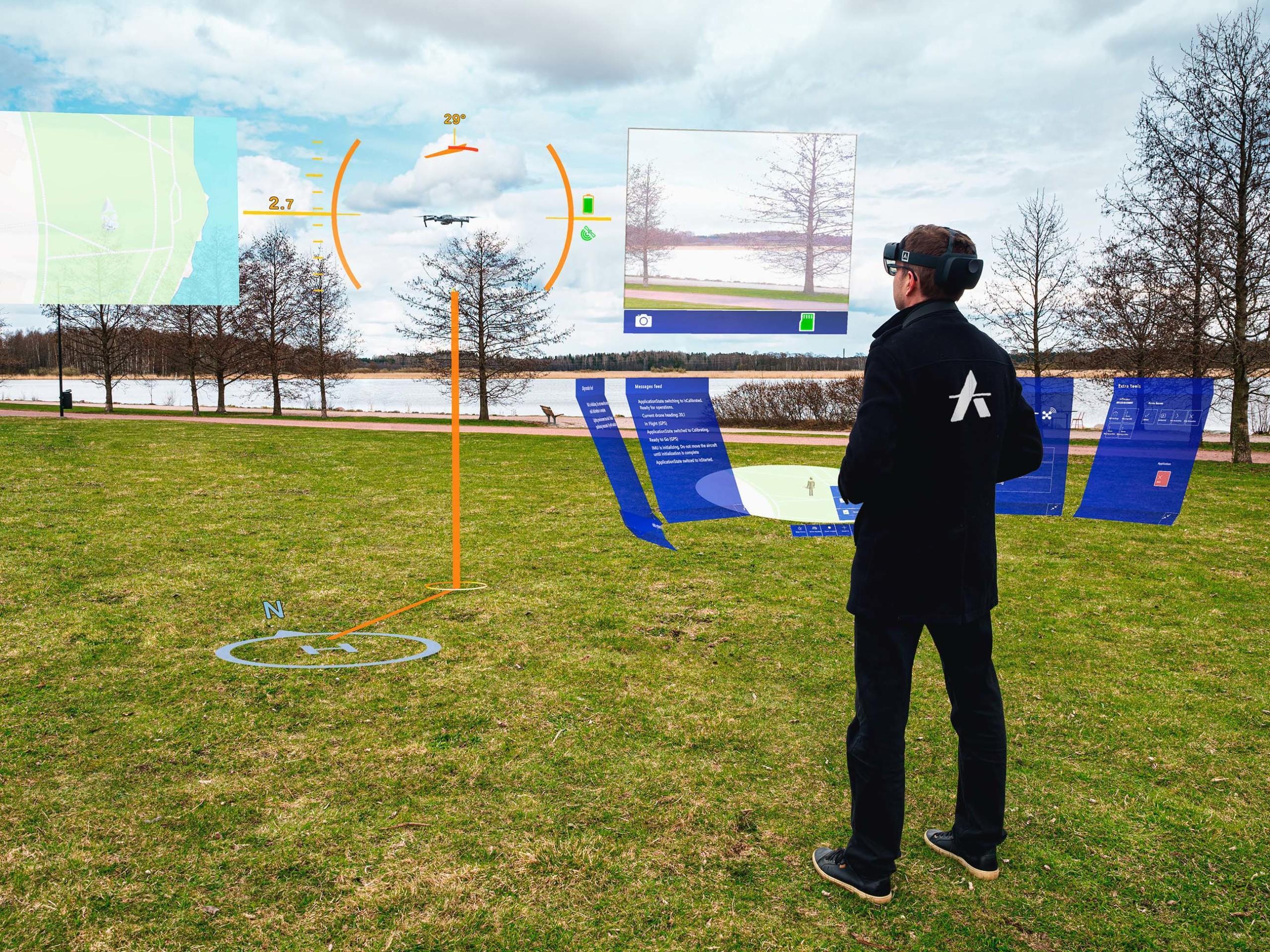
Flying a drone within visual line of sight (VLOS) is a practical example of utilizing augmented reality glasses for enhanced situational awareness. When you fly a drone using VLOS, you maintain direct visual contact with the drone at all times. This means that you can see the drone with your own eyes and monitor its flight path, position, and surroundings without relying solely on the drone’s camera feed.

By wearing augmented reality glasses while flying a drone VLOS, you can further enhance your situational awareness. These glasses overlay real-time data and information onto your field of view, providing you with valuable insights about the drone’s flight parameters, battery life, altitude, and distance from obstacles. This augmented information allows you to make more informed decisions and react quickly to any potential hazards or risks. This is exactly how AirHUD works for instance.

For example, imagine you’re flying your drone in a park. With the augmented reality glasses, you can see the drone’s exact altitude, flight speed, and remaining battery life overlaid on your field of view. If you notice that the battery is running low or that the drone is flying too close to a tree, you can take immediate action to prevent a potential crash or loss of the drone.

Augmented reality glasses can also display real-time weather conditions, GPS coordinates, and other relevant data, giving you a comprehensive understanding of your surroundings. This additional information can help you navigate through challenging environments and ensure that you maintain a safe flight path.

An example of flying EVLOS with a drone

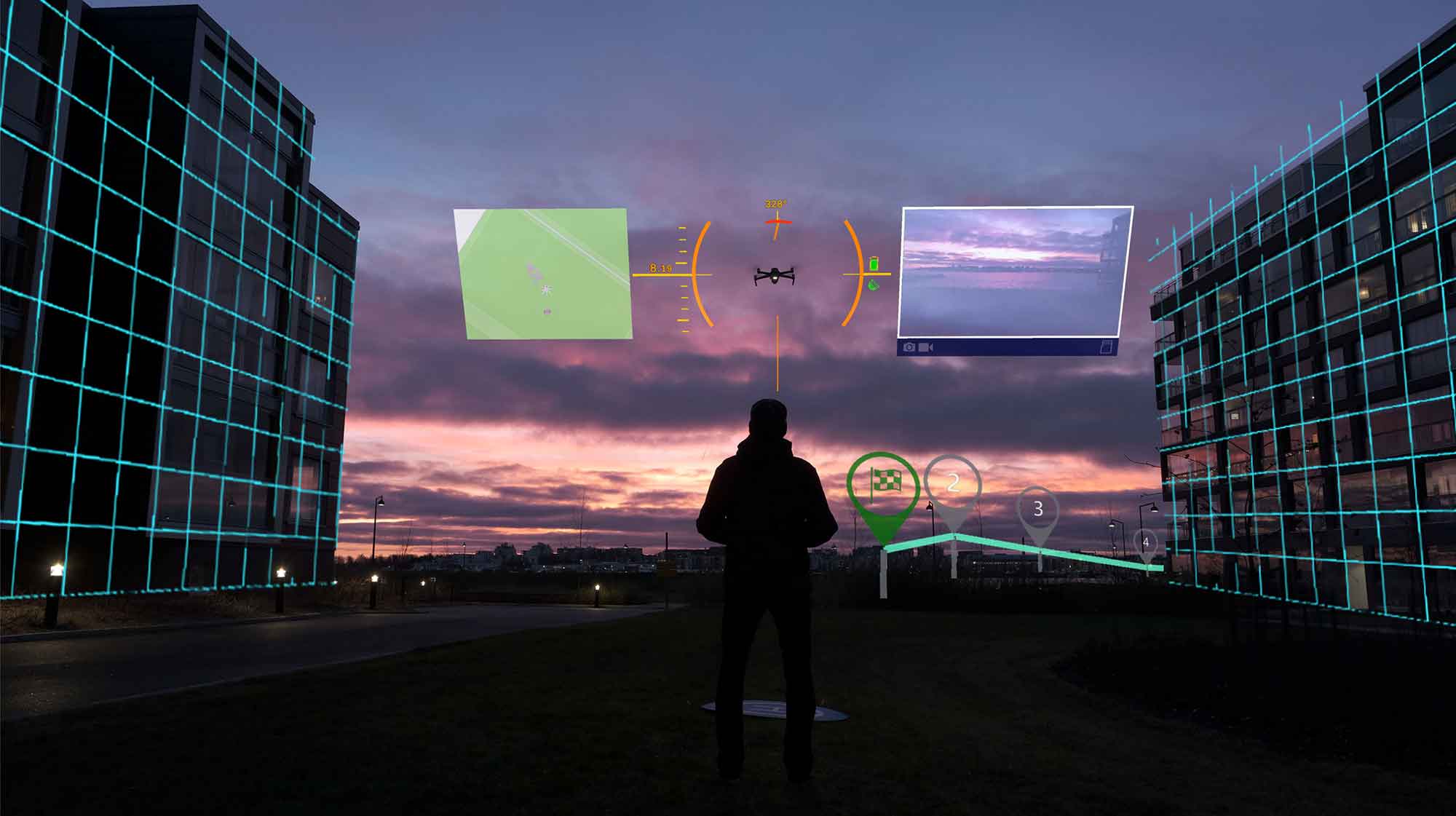
When flying a drone using extended visual line of sight (EVLOS), you can navigate the drone beyond your direct visual contact while still maintaining situational awareness. Let’s say you’re flying your drone in a large open field. Flying EVLOS, you can fly the drone up to a certain distance where it’s still visible to the naked eye, but not directly in your line of sight, however because you’re wearing the AR glasses you still see all the overlaid data and can pinpoint your drone. This allows you to explore different areas and capture unique footage without physically moving from your spot.

For example, you spot an interesting structure on the other side of the field, but it’s too far to reach with a visual line of sight (VLOS) flight. With AirHUD, you can fly the drone towards that structure while monitoring its position and surroundings through the AR Glasses, the realtime video feed and see all the related data. By constantly observing the drone’s position relative to its surroundings, you can ensure it stays within the designated boundaries and avoid any potential obstacles. This situational awareness is crucial for maintaining safety and avoiding collisions with other objects or aircraft.

As you continue flying the drone in EVLOS mode, it’s important to keep in mind the limitations and regulations set by authorities. This may include maintaining a certain altitude, flying in designated areas, or obtaining special permits for flying beyond visual line of sight (BVLOS). By adhering to these guidelines and using EVLOS responsibly, you can enjoy the freedom to explore new perspectives and capture stunning aerial footage while still prioritizing safety and situational awareness.

An example of flying BVLOS with a drone

To demonstrate the capabilities of flying beyond visual line of sight (BVLOS) with a drone, consider this scenario.

Imagine you’re a professional aerial surveyor tasked with mapping a large area of land for a construction project. The area covers several square kilometers and is located in a remote region with difficult terrain and limited road access.

With BVLOS capabilities, you can launch your drone from a designated area and fly it to the survey location without the need for a visual observer or maintaining direct line of sight. The drone is equipped with advanced sensors and cameras that allow you to capture high-resolution images and collect accurate data for the mapping project.

As you initiate the flight, you access real-time data feeds from air traffic control and other relevant sources to ensure the airspace is clear and safe. The drone autonomously navigates through pre-programmed waypoints, avoiding any obstacles or restricted areas. Throughout the flight, you maintain constant communication with the drone, receiving telemetry and sensor data, as well as live video feeds from its onboard cameras.

Despite being miles away from the drone, you have full situational awareness of its position, speed, altitude, and battery life. This information allows you to make informed decisions and adapt the flight plan if necessary. In case of any unexpected events, you can immediately take control manually and safely land the drone.

Once the survey is complete, you navigate the drone back to its designated landing zone, utilizing the BVLOS capabilities to ensure a smooth and efficient return. 

AirHUD software for instance has been specifically designed to work BVLOS and is used in industrial and emergency response environments.

This scenario showcases the immense potential of BVLOS operations, enabling professionals like you to conduct complex tasks in remote areas, saving time, resources, and increasing overall efficiency.

What other considerations are there?

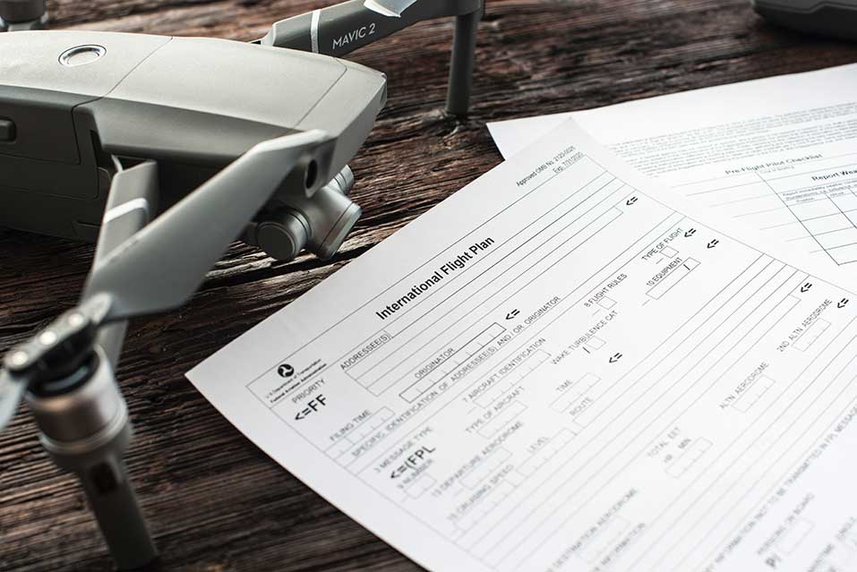
In addition, it’s important to take into account the weather conditions and airspace regulations when flying a drone. These factors play a crucial role in ensuring the safety and successful operation of your drone.

Firstly, weather conditions can significantly impact your drone’s flight. Strong winds, rain, fog, or snow can impair visibility and stability, making it difficult to control your drone. It’s essential to check the weather forecast before each flight and avoid flying in adverse conditions. Additionally, extreme temperatures can affect battery life and performance, so be mindful of the temperature range recommended by the manufacturer.

Secondly, airspace regulations are essential to follow to avoid potential conflicts with other aircraft and ensure the safe operation of your drone. Each country has its own set of rules and restrictions regarding drone flight. Familiarize yourself with these regulations, including any restrictions on altitude, distance from airports, or the need for special permits in certain areas. Ignoring airspace regulations can lead to accidents or legal consequences.

Furthermore, it’s crucial to consider the location where you intend to fly your drone. Flying in crowded areas, near buildings, or over people can pose a risk to their safety. Always choose a suitable and open area away from obstacles and people to minimize the chances of accidents or injury.

Lastly, it’s advisable to maintain a backup plan in case of unexpected situations. Always have spare batteries, extra propellers, and a first aid kit on hand. Being prepared can save you from potential setbacks and ensure a smooth flying experience.

SORA

Understanding the differences in situational awareness when flying a drone is crucial for safe and legal operations.

BVLOS (Beyond Visual Line of Sight) flights require advanced technology and strict regulations, while EVLOS (Extended Visual Line of Sight) flights allow for greater range but still require a visual connection to the drone.

VLOS (Visual Line of Sight) flights are the most common and straightforward, with the operator keeping the drone in their direct line of sight.

By adhering to the regulations and considering all factors, drone pilots can ensure a smooth and successful flight experience.

SORA stands for Specific Operations Risk Assessment and is a benchmark followed by most aviation authorities globally relating to situational awareness. Anarky Labs have committed to developing software that reduces the risk of drone operations. Our white paper on this can be found below.

Stay Informed – Heads up Display With relation to SORA Guidelines

As the drone industry continues to grow at an exciting pace, we propose that augmented reality (AR) technology can play a pivotal role in enhancing drone infrastructure.

By leveraging AR technology, we can improve safety, efficiency, and accuracy in drone operations, while also creating new opportunities for innovation and growth in the industry.

However, to fully realise the potential of AR in the drone industry, we need the backing of industry stakeholders to integrate AR into the regulatory process. This white paper presents a compelling case for why AR should be part of the regulatory process for drones, and outlines the benefits of AR for improving safety, efficiency, and accuracy in drone operations.

We call upon industry stakeholders to join us in supporting the integration of AR technology into the regulatory process, and to work together to unlock the full potential of the drone industry.